Diksia.com - Israel’s massive offensive in the Jenin region of the West Bank has ended after two days.
“The operation has officially ended and the army has left the Jenin area,” an Israeli military spokesman told the BBC.
A total of 12 Palestinians and one Israeli soldier have reportedly been killed since Monday’s attack.
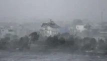
Israel has launched a large-scale military operation against the Jenin camp in the occupied West Bank.
They claim that their army is fighting against militant Palestinian groups.
But where is the Jenin camp and how big is its territory?
The refugee camp is located in the city of Jenin, north of the occupied West Bank.
This vast area is in the West Bank next to the Jordan River, which Israel captured from Jordan in the 1967 Six Day War.
Both countries, Israel and Palestine, claim the territory as their property. However, after decades of debate, the final status has yet to be determined.
Since 1995 Jenin has been under the control of the Palestinian Authority, which also occupies parts of the West Bank – not under direct Israeli rule.
But since then, the Israeli army has entered the camp several times to conduct security operations.
The camp consists of concrete buildings that were first constructed in the 1970s.
According to the United Nations Relief and Works Agency (UNRWA), 14,000 people live in the region. They live in an area of less than half a square kilometer.
According to UNRWA, Jenin camp has high levels of poverty and unemployment, particularly among young people.
This then leads to widespread feelings of dissatisfaction and frustration. Poverty and unemployment have also contributed to the rise in school dropout rates among children.
Violence in the city of Jenin and local camps has continued to escalate over the past week.
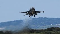
In an Israeli attack on Jenin on June 20, seven Palestinians were killed when a war helicopter was deployed.
The next day, two Hamas soldiers shot dead four Israelis at a gas station and restaurant near the settlement of Eli, 40 kilometers south of Jenin.